
Make a donation
Juiz de Fora topographic map
Click on the map to display elevation.
Make a donation
Juiz de Fora
Although lying within tropical latitudes the climate is relatively mild. The altitude of 700 to 900 m (2,300 to 3,000 ft) makes the weather usually cooler and rainier than the lower surrounding areas. Under the Köppen climate classification Juiz de Fora's climate is classified as a humid subtropical climate with two distinct seasons, one hotter and rainier (October to April) and one cooler and drier (May to September). The average annual temperature is around 19 °C (66 °F) with an average high of 24 °C (75 °F) and an average low of 15 °C (59 °F). It is very humid with average humidity of 80%. The annual rainfall varies between 1,300 and 1,500 mm (51 and 59 in).
Make a donation
About this map
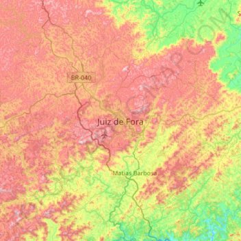
Name: Juiz de Fora topographic map, elevation, terrain.
Average elevation: 675 m
Minimum elevation: 301 m
Maximum elevation: 1,089 m
Make a donation
Other topographic maps
Click on a map to view its topography, its elevation and its terrain.
Itamarati
Brazil > Minas Gerais > Região Metropolitana de Belo Horizonte > Belo Horizonte
Average elevation: 831 m