
Make a donation
Pierce County topographic map
Click on the map to display elevation.
Make a donation
About this map
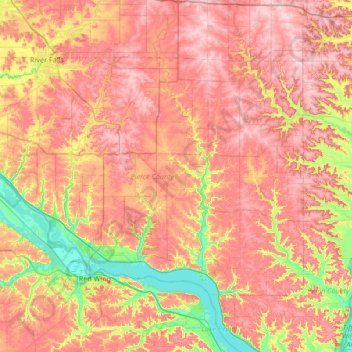
Name: Pierce County topographic map, elevation, terrain.
Location: Pierce County, Wisconsin, United States (44.53941 -92.80751 44.86268 -92.13488)
Average elevation: 308 m
Minimum elevation: 199 m
Maximum elevation: 392 m
Make a donation
Other topographic maps
Click on a map to view its topography, its elevation and its terrain.
Madison
United States > Wisconsin > Dane County
The city is sometimes described as The City of Four Lakes, comprising the four successive lakes of the Yahara River: Lake Mendota ("Fourth Lake"), Lake Monona ("Third Lake"), Lake Waubesa ("Second Lake") and Lake Kegonsa ("First Lake"), although Waubesa and Kegonsa are not actually in Madison, but just south…
Average elevation: 289 m
Village of West Salem
United States > Wisconsin > La Crosse County > West Salem
Average elevation: 226 m
Make a donation
Make a donation
Make a donation
Make a donation
Make a donation
Lynn
United States > Wisconsin > Clark County
The history of Lynn, Wisconsin is deeply rooted in the early settlement and development of Clark County. Topics covered in the history of Clark County, Wisconsin, include topography, Indians, early government, early settlement, politics, lumbering, transportation, agriculture, education, the press, the courts,…
Average elevation: 355 m
Make a donation
Mississippi River
United States > Wisconsin > Grant County > Dubuque
The uppermost lock and dam on the Upper Mississippi River is the Upper St. Anthony Falls Lock and Dam in Minneapolis. Above the dam, the river's elevation is 799 feet (244 m). Below the dam, the river's elevation is 750 feet (230 m). This 49-foot (15 m) drop is the largest of all the Mississippi River locks…
Average elevation: 203 m
Spirit Lake
United States > Wisconsin > Sauk County
Devils Lake State Park offers 29 miles of hiking trails that vary based on difficulty level, length, and terrain. Among the 17 established trails, the most popular is the tumbled rocks trail. It sits at the edge of the lake on the west end, stretching a mile long. The trail is paved, allowing it to be…
Average elevation: 349 m
Make a donation
Aztalan State Park
United States > Wisconsin > Jefferson County > Town of Aztalan
Average elevation: 255 m
Make a donation
Make a donation
Make a donation
Make a donation
Big Manitou Falls
United States > Wisconsin > Douglas County > Town of Superior
Average elevation: 295 m
Make a donation
Make a donation
Make a donation
Make a donation
Natural Bridge State Park
United States > Wisconsin > Sauk County > North Freedom
Average elevation: 289 m
Pinehurst Park
United States > Wisconsin > Eau Claire County > Eau Claire > Pinehurst
Average elevation: 289 m
Make a donation
Make a donation
Make a donation
Make a donation
Glacial Valley Park
United States > Wisconsin > Dane County > Village of Cross Plains
Average elevation: 287 m
Make a donation
Lead Mine
United States > Wisconsin > Lafayette County > Town of New Diggings
Average elevation: 264 m
Calumet County Park
United States > Wisconsin > Calumet County > Rockaway Beach
Average elevation: 257 m
Make a donation
Make a donation
Danbury
United States > Wisconsin > Burnett County
Danbury is located at 46.006N. The longitude is -92.371W. It is in the Central Standard Time Zone. The elevation is 938 feet (286 m) above sea level.
Average elevation: 287 m
Make a donation
Make a donation
Make a donation