
Thank you for supporting this site ❤️
Make a donation
Make a donation
Santa Teresita topographic map
Click on the map to display elevation.
Thank you for supporting this site ❤️
Make a donation
Make a donation
About this map
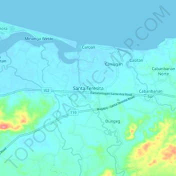
Name: Santa Teresita topographic map, elevation, terrain.
Location: Santa Teresita, Cagayan, Cagayan Valley, 3512, Philippines (18.20961 121.86928 18.28961 121.94928)
Average elevation: 12 m
Minimum elevation: -4 m
Maximum elevation: 116 m
Thank you for supporting this site ❤️
Make a donation
Make a donation
Other topographic maps
Click on a map to view its topography, its elevation and its terrain.
Fuga Island
Fuga has an area of 70 square kilometres (27 sq mi) and a population of 2,015 people. The principal settlement is Naguilian (Musa) village on the southern coast. The highest peak is Mount Nanguringan in the northeast, with an elevation of 191 metres (627 ft).
Average elevation: 9 m
Thank you for supporting this site ❤️
Make a donation
Make a donation