
Frankton Arm topographic map
Interactive map
Click on the map to display elevation.
About this map
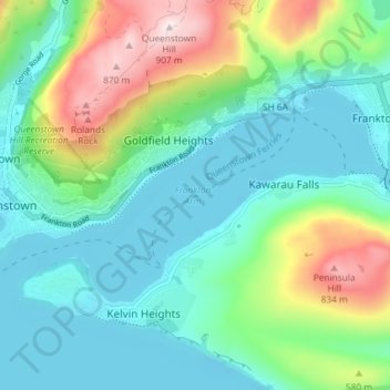
Name: Frankton Arm topographic map, elevation, terrain.
Average elevation: 462 m
Minimum elevation: 304 m
Maximum elevation: 902 m
Other topographic maps
Click on a map to view its topography, its elevation and its terrain.
Kelvin Peninsula
New Zealand > Otago > Queenstown-Lakes District > Queenstown
Kelvin Peninsula, Kelvin Heights, Queenstown, Queenstown-Lakes District, Otago, 9300, New Zealand
Average elevation: 372 m