
Thank you for supporting this site ❤️
Make a donation
Make a donation
Salmon Arm topographic map
Click on the map to display elevation.
Thank you for supporting this site ❤️
Make a donation
Make a donation
About this map
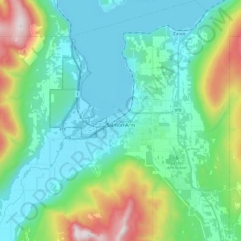
Name: Salmon Arm topographic map, elevation, terrain.
Average elevation: 620 m
Minimum elevation: 343 m
Maximum elevation: 1,542 m
Thank you for supporting this site ❤️
Make a donation
Make a donation
Other topographic maps
Click on a map to view its topography, its elevation and its terrain.
Lyell Creek
Canada > British Columbia > Columbia-Shuswap Regional District > Area A (Kicking Horse/Kinbasket Lake)
Average elevation: 1,323 m