
Make a donation
Watauga County topographic map
Click on the map to display elevation.
Make a donation
Watauga County
Watauga County is extremely mountainous, and all of the county's terrain is located within the Appalachian Mountains range. The highest point in the county is Calloway Peak, the highest peak of Grandfather Mountain (shared with the adjacent counties of Avery and Caldwell), which rises to 5,964 feet (1,818 meters) above sea level. At an elevation of 5,506 feet (1,678 meters) above sea level, Beech Mountain is the highest incorporated community east of the Mississippi River. Boone, the county's largest city and county seat, has the highest elevation (3,333 feet) of any city over 10,000 population in the Eastern United States.
Make a donation
About this map
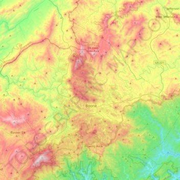
Name: Watauga County topographic map, elevation, terrain.
Location: Watauga County, North Carolina, United States (36.11147 -81.91812 36.39129 -81.45580)
Average elevation: 984 m
Minimum elevation: 378 m
Maximum elevation: 1,777 m
Make a donation
Other topographic maps
Click on a map to view its topography, its elevation and its terrain.
Country Club Estates
United States > North Carolina > Alamance County > Burlington
Average elevation: 195 m
Make a donation
Make a donation
Make a donation