
Anglesey topographic map
Click on the map to display elevation.
About this map
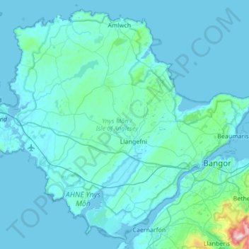
Name: Anglesey topographic map, elevation, terrain.
Location: Anglesey, Isle of Anglesey, Wales, United Kingdom (53.12636 -4.58854 53.43007 -4.04016)
Average elevation: 43 m
Minimum elevation: -1 m
Maximum elevation: 895 m
Other topographic maps
Click on a map to view its topography, its elevation and its terrain.
Llanfihangel yn Nhowyn
United Kingdom > Wales > Isle of Anglesey > Caergeiliog
Average elevation: 13 m