
Thank you for supporting this site ❤️
Make a donation
Make a donation
Aveley topographic map
Click on the map to display elevation.
Thank you for supporting this site ❤️
Make a donation
Make a donation
About this map
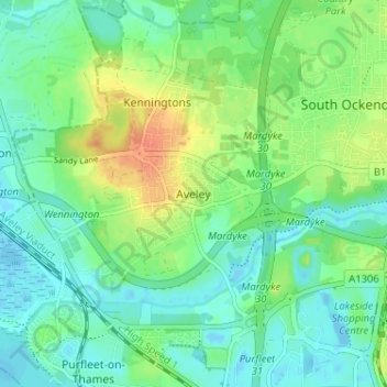
Name: Aveley topographic map, elevation, terrain.
Location: Aveley, Thurrock, Essex, England, RM15 4TJ, United Kingdom (51.48011 0.23618 51.52011 0.27618)
Average elevation: 13 m
Minimum elevation: -13 m
Maximum elevation: 39 m
Thank you for supporting this site ❤️
Make a donation
Make a donation
Other topographic maps
Click on a map to view its topography, its elevation and its terrain.
Thank you for supporting this site ❤️
Make a donation
Make a donation
Thank you for supporting this site ❤️
Make a donation
Make a donation