
Karlsruhe topographic map
Interactive map
Click on the map to display elevation.
About this map
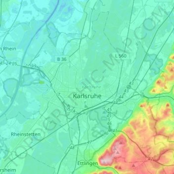
Name: Karlsruhe topographic map, elevation, terrain.
Location: Karlsruhe, Baden-Württemberg, Germany (48.94047 8.27731 49.09128 8.54173)
Average elevation: 132 m
Minimum elevation: 94 m
Maximum elevation: 349 m
Other topographic maps
Click on a map to view its topography, its elevation and its terrain.
Südweststadt
Germany > Baden-Württemberg > Karlsruhe
Südweststadt, Karlsruhe, Regierungsbezirk Karlsruhe, Baden-Württemberg, Germany
Average elevation: 119 m