
Thank you for supporting this site ❤️
Make a donation
Make a donation
Homewood topographic map
Click on the map to display elevation.
Thank you for supporting this site ❤️
Make a donation
Make a donation
About this map
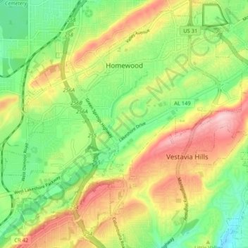
Name: Homewood topographic map, elevation, terrain.
Location: Homewood, Jefferson County, Alabama, United States (33.42651 -86.84887 33.48876 -86.76806)
Average elevation: 233 m
Minimum elevation: 140 m
Maximum elevation: 354 m
Thank you for supporting this site ❤️
Make a donation
Make a donation
Other topographic maps
Click on a map to view its topography, its elevation and its terrain.