
Massa topographic map
Interactive map
Click on the map to display elevation.
About this map
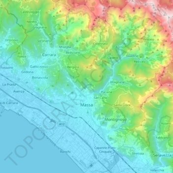
Name: Massa topographic map, elevation, terrain.
Location: Massa, MS, Tuscany, Italy (43.98016 10.05978 44.12307 10.24304)
Average elevation: 391 m
Minimum elevation: -1 m
Maximum elevation: 1,864 m
Other topographic maps
Click on a map to view its topography, its elevation and its terrain.
Prati della Ciocca
Italy > Tuscany > Massa > Prati della Ciocca
Prati della Ciocca, Massa, Massa-Carrara, Tuscany, 54100, Italy
Average elevation: 434 m