
Rolfs topographic map
Interactive map
Click on the map to display elevation.
About this map
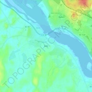
Name: Rolfs topographic map, elevation, terrain.
Average elevation: 10 m
Minimum elevation: -3 m
Maximum elevation: 48 m
Other topographic maps
Click on a map to view its topography, its elevation and its terrain.
Innanbäcken
Sweden > Norrbotten County > Rolfs > Innanbäcken
Innanbäcken, Rolfs, Kalix kommun, Norrbotten County, Region Norrland, 952 32, Sweden
Average elevation: 12 m