
Staffordshire Moorlands topographic map
Interactive map
Click on the map to display elevation.
About this map
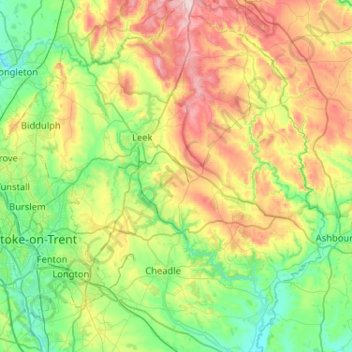
Name: Staffordshire Moorlands topographic map, elevation, terrain.
Average elevation: 227 m
Minimum elevation: 75 m
Maximum elevation: 548 m
Other topographic maps
Click on a map to view its topography, its elevation and its terrain.
Biddulph
United Kingdom > England > Staffordshire Moorlands > Biddulph
Biddulph, Staffordshire Moorlands, Staffordshire, West Midlands, England, ST8 6DU, United Kingdom
Average elevation: 205 m