
Waiotapu topographic map
Interactive map
Click on the map to display elevation.
About this map
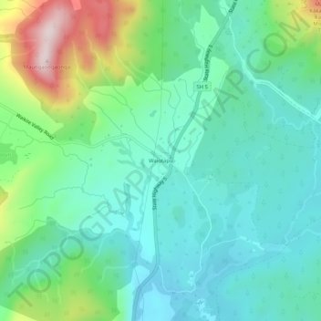
Name: Waiotapu topographic map, elevation, terrain.
Location: Waiotapu, Rotorua Lakes District, Waikato, New Zealand (-38.35951 176.34205 -38.31951 176.38205)
Average elevation: 446 m
Minimum elevation: 323 m
Maximum elevation: 799 m
Other topographic maps
Click on a map to view its topography, its elevation and its terrain.
Horohoro
New Zealand > Waikato > Rotorua Lakes District
Horohoro, Rotorua Lakes District, Waikato, New Zealand
Average elevation: 509 m