
Saitama Prefecture topographic map
Interactive map
Click on the map to display elevation.
About this map
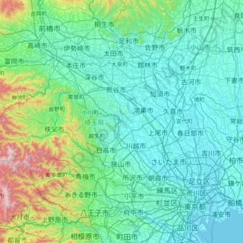
Name: Saitama Prefecture topographic map, elevation, terrain.
Location: Saitama Prefecture, Japan (35.75338 138.71136 36.28341 139.90033)
Average elevation: 230 m
Minimum elevation: -3 m
Maximum elevation: 2,041 m
The topography of Saitama Prefecture is largely divided by the Hachiōji Tectonic Line, which runs through Kodama, Ogawa, and Hannō, into the western mountain area and the eastern lowland area. The altitude, highest on the western side, gradually lowers eastward from mountain ranges to hills to plateaus to lowlands. The eastern lowlands and plateaus occupy 67.3% of the area.
Other topographic maps
Click on a map to view its topography, its elevation and its terrain.
Motegi
Motegi, Haga County, Tochigi Prefecture, 321-3531, Japan
Average elevation: 145 m
Yamanouchi
Yamanouchi, Shimotakai County, Nagano Prefecture, Chubu Region, Japan
Average elevation: 942 m
Ogawara
Ogawara, Shibata County, Miyagi Prefecture, Japan
Average elevation: 40 m
Kami
Japan > Mikata County > Kami
Kami, Mikata County, Hyogo Prefecture, Japan
Average elevation: 172 m
Okinoshima
Japan > Oki County > Okinoshima
Okinoshima, Oki County, Shimane Prefecture, 6858585, Japan
Average elevation: 10 m
Nakanojo
Japan > Agatsuma County > Nakanojo
Nakanojo, Agatsuma County, Gunma Prefecture, Japan
Average elevation: 882 m
Osaka
Japan > Kinki Region > Osaka
Kita, Osaka, Osaka Prefecture, Kinki Region, Japan
Average elevation: 10 m
Miyashitadori
Japan > Asahikawa > Miyashitadori
Miyashitadori, Asahikawa, Kamikawa Subprefecture, Hokkaido Prefecture, 070-0030, Japan
Average elevation: 118 m