
Barbuda topographic map
Interactive map
Click on the map to display elevation.
About this map
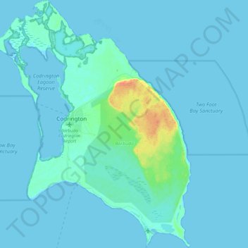
Name: Barbuda topographic map, elevation, terrain.
Location: Barbuda, Antigua and Barbuda (17.54295 -61.88713 17.72911 -61.73139)
Average elevation: 4 m
Minimum elevation: -3 m
Maximum elevation: 45 m
The total land area is 160.56 square kilometres (62 sq mi). The capital and largest town is Codrington, with an estimated population of 1,300 (2011 Estimated). The island is mostly coral limestone with little topographical variation. The "highlands" area on the eastern side of the island has hills rising to 125 ft (38 m), but the majority of the island is very flat, with many lagoons in the northwest corner.