
Cedar Hill topographic map
Interactive map
Click on the map to display elevation.
Cedar Hill
It is sometimes referred to as the "hill country of Dallas" (in comparison to the "hill country" surrounding Austin and San Antonio). The city is full of native eastern red cedar evergreen trees and stands at an elevation of about 800 feet (240 m) above sea level—the highest point in a straight line from the Red River at the Texas-Oklahoma border to the Gulf Coast.
About this map
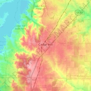
Name: Cedar Hill topographic map, elevation, terrain.
Location: Cedar Hill, Dallas County, Texas, United States of America (32.53492 -97.02123 32.63941 -96.89043)
Average elevation: 214 m
Minimum elevation: 156 m
Maximum elevation: 268 m