
Aiguilles Island topographic map
Interactive map
Click on the map to display elevation.
About this map
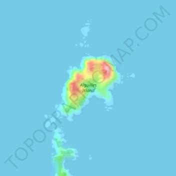
Name: Aiguilles Island topographic map, elevation, terrain.
Location: Aiguilles Island, Great Barrier, Auckland, New Zealand (-36.03977 175.40161 -36.02963 175.41390)
Average elevation: 5 m
Minimum elevation: -2 m
Maximum elevation: 146 m
Other topographic maps
Click on a map to view its topography, its elevation and its terrain.
Kaikoura Island
New Zealand > Auckland > Great Barrier
Kaikoura Island, Great Barrier, Auckland, New Zealand
Average elevation: 28 m
Motutaiko Island
New Zealand > Auckland > Great Barrier
Motutaiko Island, Great Barrier, Auckland, New Zealand
Average elevation: 2 m
Little Barrier Island
New Zealand > Auckland > Great Barrier
Little Barrier Island, Great Barrier, Auckland, New Zealand
Average elevation: 12 m