
Erromango topographic map
Interactive map
Click on the map to display elevation.
About this map
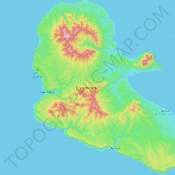
Name: Erromango topographic map, elevation, terrain.
Location: Erromango, Tafea, Vanuatu (-18.99592 168.98628 -18.62136 169.34384)
Average elevation: 118 m
Minimum elevation: 0 m
Maximum elevation: 861 m
Other topographic maps
Click on a map to view its topography, its elevation and its terrain.