
New Haven County topographic map
Interactive map
Click on the map to display elevation.
About this map
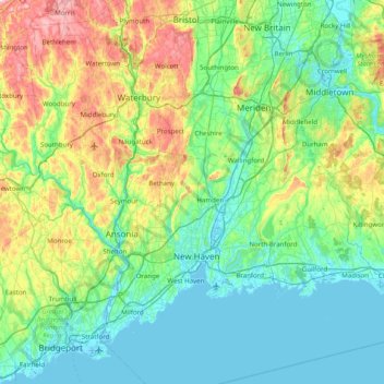
Name: New Haven County topographic map, elevation, terrain.
Location: New Haven County, Connecticut, USA (41.16932 -73.32726 41.64411 -72.53627)
Average elevation: 89 m
Minimum elevation: -5 m
Maximum elevation: 385 m
Other topographic maps
Click on a map to view its topography, its elevation and its terrain.
Falls River
Falls River, Middlesex County, Connecticut, 06426, USA
Average elevation: 27 m
Major Island
Major Island, New London County, Connecticut, USA
Average elevation: 16 m
Bell Island
USA > Connecticut > Norwalk
Bell Island, Norwalk, Fairfield, Connecticut, 06853, USA
Average elevation: 63 m
Cromwell
USA > Connecticut > Cromwell
Cromwell, Middlesex County, Connecticut, 06480, USA
Average elevation: 31 m