
Stillwater River topographic map
Interactive map
Click on the map to display elevation.
About this map
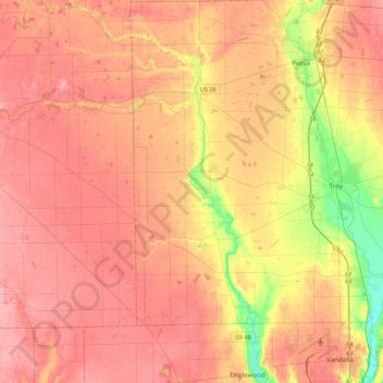
Name: Stillwater River topographic map, elevation, terrain.
Location: Stillwater River, Miami County, Ohio, 45318, USA (39.87037 -84.55341 40.19810 -84.28606)
Average elevation: 295 m
Minimum elevation: 234 m
Maximum elevation: 330 m
Other topographic maps
Click on a map to view its topography, its elevation and its terrain.
Westerville
USA > Ohio > Westerville
Westerville, Franklin County, Ohio, 43081, USA
Average elevation: 267 m
Sylvan Shores
USA > Ohio > Sylvan Shores
Sylvan Shores, Clark County, Ohio, 45369, USA
Average elevation: 367 m
Cheviot Hills
USA > Ohio > Cheviot Hills
Cheviot Hills, Clark County, Ohio, 45505, USA
Average elevation: 321 m
Burton Lake
USA > Ohio > Burton Lake
Burton Lake, Burton Township, Geauga County, Ohio, 44021, USA
Average elevation: 348 m