
Multnomah County topographic map
Interactive map
Click on the map to display elevation.
About this map
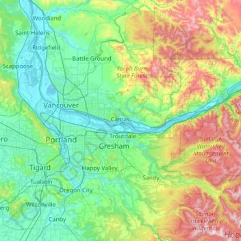
Name: Multnomah County topographic map, elevation, terrain.
Location: Multnomah County, Oregon, United States (45.43263 -122.92921 45.72865 -121.81967)
Average elevation: 334 m
Minimum elevation: -2 m
Maximum elevation: 1,519 m
Other topographic maps
Click on a map to view its topography, its elevation and its terrain.
Lake Oswego
United States > Oregon > Clackamas County
Lake Oswego, Clackamas County, Oregon, United States
Average elevation: 87 m
Lane County
United States > Oregon > Lane County
Lane County, Oregon, United States
Average elevation: 712 m
Coalmine Hill
United States > Oregon > Morrow County
Coalmine Hill, Morrow County, Oregon, United States
Average elevation: 1,486 m
Portland
United States > Oregon > Multnomah County
Portland, Multnomah County, Oregon, United States
Average elevation: 77 m
Summit Point
Summit Point, Baker County, Oregon, United States
Average elevation: 1,911 m
Eagle Point
United States > Oregon > Eagle Point
Eagle Point, Jackson County, Oregon, 97524, United States
Average elevation: 422 m
Corvallis
United States > Oregon > Benton County
Corvallis, Benton County, Oregon, United States
Average elevation: 81 m
Eugene
United States > Oregon > Lane County
Eugene, Lane County, Oregon, United States
Average elevation: 163 m
Clackamas County
Clackamas County, Oregon, United States
Average elevation: 660 m
Mount Hood
United States > Oregon > Hood River County
Mount Hood, Hood River County, Oregon, United States
Average elevation: 2,716 m