
Cherwell topographic map
Interactive map
Click on the map to display elevation.
About this map
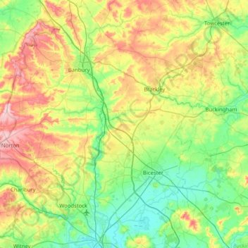
Name: Cherwell topographic map, elevation, terrain.
Location: Cherwell, Oxfordshire, South East, England, United Kingdom (51.78096 -1.52284 52.16847 -1.04714)
Average elevation: 116 m
Minimum elevation: 56 m
Maximum elevation: 240 m
Other topographic maps
Click on a map to view its topography, its elevation and its terrain.
Begbroke
United Kingdom > England > Cherwell > Begbroke
Begbroke, Cherwell, Oxfordshire, South East, England, OX5 1RQ, United Kingdom
Average elevation: 75 m
Kidlington
United Kingdom > England > Cherwell > Kidlington
Kidlington, Cherwell, Oxfordshire, South East, England, OX5, United Kingdom
Average elevation: 66 m