
Ganderbal topographic map
Interactive map
Click on the map to display elevation.
About this map
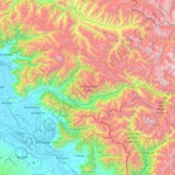
Name: Ganderbal topographic map, elevation, terrain.
Location: Ganderbal, Jammu and Kashmir, India (34.11863 74.65815 34.46354 75.49873)
Average elevation: 3,086 m
Minimum elevation: 1,576 m
Maximum elevation: 5,416 m
Ganderbal district, with its district headquarters located at 33°44′N 75°09′E / 33.73°N 75.15°E / 33.73; 75.15, at an average elevation of 1,950 metres (6,400 ft) above sea level, at a distance of 21 kilometres (13 mi) from Srinagar city.
Other topographic maps
Click on a map to view its topography, its elevation and its terrain.
Udhampur
Udhampur, Udhampur District, Jammu and Kashmir, India
Average elevation: 1,292 m
South Rimo Glacier
South Rimo Glacier, Leh District, Jammu and Kashmir, India
Average elevation: 5,595 m
Anantnag
India > Jammu and Kashmir > Anantnag
Anantnag, Jammu and Kashmir, India
Average elevation: 1,785 m
Nun
Nun, Kargil District, Jammu and Kashmir, India
Average elevation: 5,988 m
Siachen Glacier
Siachen Glacier, Leh District, Jammu and Kashmir, India
Average elevation: 5,448 m