
Örebro County topographic map
Interactive map
Click on the map to display elevation.
About this map
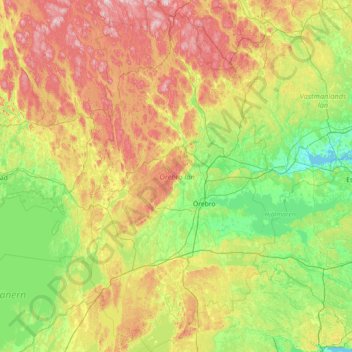
Name: Örebro County topographic map, elevation, terrain.
Location: Örebro County, Region Svealand, Sweden (58.64623 14.28523 60.11087 15.79853)
Average elevation: 122 m
Minimum elevation: -1 m
Maximum elevation: 466 m
Other topographic maps
Click on a map to view its topography, its elevation and its terrain.
Brevens bruk
Sweden > Örebro County > Brevens bruk
Brevens bruk, Örebro, Örebro County, Region Svealand, 715 96, Sweden
Average elevation: 93 m
Tomtabacken
Sweden > Örebro County > Blåberga
Tomtabacken, Blåberga, Hallsberg, Province Närke, Örebro County, Region Svealand, 69491, Sweden
Average elevation: 72 m