
Utah topographic map
Interactive map
Click on the map to display elevation.
About this map
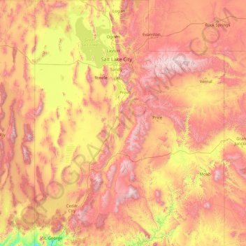
Name: Utah topographic map, elevation, terrain.
Location: Utah, United States (36.99781 -114.05285 42.00170 -109.04158)
Average elevation: 1,876 m
Minimum elevation: 789 m
Maximum elevation: 3,986 m
Western Utah is a mostly arid desert with a basin and range topography. Small mountain ranges and rugged terrain punctuate the landscape. The Bonneville Salt Flats are an exception, being comparatively flat as a result of once forming the bed of ancient Lake Bonneville. Great Salt Lake, Utah Lake, Sevier Lake, and Rush Lake are all remnants of this ancient freshwater lake, which once covered most of the eastern Great Basin. West of the Great Salt Lake, stretching to the Nevada border, lies the arid Great Salt Lake Desert. One exception to this aridity is Snake Valley, which is (relatively) lush due to large springs and wetlands fed from groundwater derived from snow melt in the Snake Range, Deep Creek Range, and other tall mountains to the west of Snake Valley. Great Basin National Park is just over the Nevada state line in the southern Snake Range. One of western Utah's most impressive, but least visited attractions is Notch Peak, the tallest limestone cliff in North America, located west of Delta.
Other topographic maps
Click on a map to view its topography, its elevation and its terrain.
Las Vegas
United States > Nevada > Clark County
Las Vegas, Clark County, Nevada, United States
Average elevation: 756 m
The Villages
United States > Florida > Sumter County
The Villages, Sumter County, Florida, United States
Average elevation: 25 m
Nashville-Davidson
United States > Tennessee > Davidson County
Nashville-Davidson, Davidson County, Middle Tennessee, Tennessee, United States
Average elevation: 184 m
San Dimas
San Dimas, California, 91773, United States
Average elevation: 355 m
Craigsville
United States > West Virginia > Nicholas County > Craigsville
Craigsville, Nicholas County, West Virginia, 26205, United States
Average elevation: 692 m
Splash Island
United States > Indiana > Hendricks County > Plainfield
Splash Island, Pike Lane, Plainfield, Hendricks County, Indiana, 46168, United States
Average elevation: 232 m
Chanceford Township
United States > Pennsylvania > York County
Chanceford Township, York County, Pennsylvania, 17309, United States
Average elevation: 192 m
Virgin Islands
United States > United States Virgin Islands > Saint Croix District
Virgin Islands, Saint Croix District, United States Virgin Islands, United States
Average elevation: 2 m
Tancred
United States > California > Yolo County
Tancred, Yolo County, California, 95606, United States
Average elevation: 112 m
Miles
United States > Iowa > Jackson County
Miles, Jackson County, Iowa, United States
Average elevation: 248 m
Roswell
United States > Georgia > Fulton County
Roswell, Fulton County, Georgia, United States
Average elevation: 316 m
Ward 7
United States > District of Columbia > Washington
Ward 7, Washington, District of Columbia, 20019, United States
Average elevation: 38 m
Liberty
United States > Kentucky > Casey County
Liberty, Casey County, Kentucky, United States
Average elevation: 276 m
Deepwater
United States > Missouri > Henry County
Deepwater, Henry County, Missouri, United States
Average elevation: 231 m
Vail
United States > Colorado > Eagle County
Vail, Eagle County, Colorado, 81657, United States
Average elevation: 2,953 m
Barrier Range
United States > Alaska > Kodiak Island
Barrier Range, Kodiak Island, Alaska, United States
Average elevation: 456 m
Thornton
United States > Colorado > Adams County
Thornton, Adams County, Colorado, United States
Average elevation: 1,601 m
Kenilworth
United States > Illinois > Cook County
Kenilworth, New Trier Township, Cook County, Illinois, United States
Average elevation: 188 m
Montrose County
Montrose County, Colorado, United States
Average elevation: 2,307 m
Reno
United States > Texas > Parker County
Reno, Parker County, Texas, United States
Average elevation: 233 m
Johnsonville
United States > Illinois > Wayne County
Johnsonville, Indian Prairie Township, Wayne County, Illinois, United States
Average elevation: 158 m
South Haven Charter Township
United States > Michigan > Van Buren County
South Haven Charter Township, Van Buren County, Michigan, 49090, United States
Average elevation: 191 m
Park City
United States > Utah > Summit County
Park City, Summit County, Utah, United States
Average elevation: 2,290 m
Clive
United States > Iowa > Polk County
Clive, Polk County, Iowa, 50325, United States
Average elevation: 287 m
Plano
United States > Texas > Collin County
Plano, Collin County, Texas, United States
Average elevation: 196 m
Niles
United States > Ohio > Trumbull County > Weathersfield Township
Niles, Weathersfield Township, Trumbull County, Ohio, 44446, United States
Average elevation: 280 m
Orono
United States > Maine > Penobscot County
Orono, Penobscot County, Maine, United States
Average elevation: 44 m
Oshkosh
United States > Wisconsin > Winnebago County
Oshkosh, Winnebago County, Wisconsin, United States
Average elevation: 235 m
Grand Prairie
United States > Texas > Dallas County
Grand Prairie, Dallas County, Texas, United States
Average elevation: 181 m
Stockton
United States > California > San Joaquin County
Stockton, San Joaquin County, California, United States
Average elevation: 7 m
Dover
United States > New Hampshire > Strafford County
Dover, Strafford County, New Hampshire, 03820, United States
Average elevation: 31 m
San Antonio
United States > Texas > Bexar County
San Antonio, Bexar County, Texas, United States
Average elevation: 247 m
Springs Junction
United States > Alabama > Shelby County
Springs Junction, Shelby County, Alabama, United States
Average elevation: 177 m
Orlando
United States > Florida > Orange County
Orlando, Orange County, Florida, United States
Average elevation: 30 m
Leptondale
United States > New York > Orange County > Orange Lake
Leptondale, Orange Lake, Town of Newburgh, Orange County, New York, 12560, United States
Average elevation: 162 m
Murchison
United States > Texas > Henderson County
Murchison, Henderson County, Texas, United States
Average elevation: 146 m
Irvine
United States > California > Orange County
Irvine, Orange County, California, United States
Average elevation: 66 m
Rodeo
United States > California > Contra Costa County
Rodeo, Contra Costa County, California, 94572, United States
Average elevation: 20 m
East Centreville
United States > Alabama > Bibb County > Centreville
East Centreville, Centreville, Bibb County, Alabama, 35042, United States
Average elevation: 77 m
Tiltonsville
United States > Ohio > Jefferson County
Tiltonsville, Jefferson County, Ohio, 43963, United States
Average elevation: 251 m
St. Clairsville
United States > Ohio > Belmont County
St. Clairsville, Belmont County, Ohio, 43950, United States
Average elevation: 355 m
Leesburg
United States > Florida > Lake County
Leesburg, Lake County, Florida, United States
Average elevation: 26 m
Woodmont
United States > West Virginia > Morgan County
Woodmont, Morgan County, West Virginia, United States
Average elevation: 204 m
Swampscott
United States > Massachusetts > Essex County
Swampscott, Essex County, Massachusetts, 01907, United States
Average elevation: 8 m