
Argentina topographic map
Interactive map
Click on the map to display elevation.
About this map
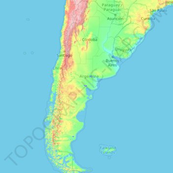
Name: Argentina topographic map, elevation, terrain.
Location: Argentina (-55.19257 -73.56054 -21.78086 -53.63745)
Average elevation: 198 m
Minimum elevation: -2 m
Maximum elevation: 6,482 m
Major wind currents include the cool Pampero Winds blowing on the flat plains of Patagonia and the Pampas; following the cold front, warm currents blow from the north in middle and late winter, creating mild conditions. The Sudestada usually moderates cold temperatures but brings very heavy rains, rough seas and coastal flooding. It is most common in late autumn and winter along the central coast and in the Río de la Plata estuary. The Zonda, a hot dry wind, affects Cuyo and the central Pampas. Squeezed of all moisture during the 6,000 m (19,685 ft) descent from the Andes, Zonda winds can blow for hours with gusts up to 120 km/h (75 mph), fueling wildfires and causing damage; between June and November, when the Zonda blows, snowstorms and blizzard (viento blanco) conditions usually affect higher elevations.
Other topographic maps
Click on a map to view its topography, its elevation and its terrain.
Philippines
Philippines
Average elevation: 33 m
Las Vegas
United States > Nevada > Clark County
Las Vegas, Clark County, Nevada, United States
Average elevation: 756 m
Ruru
New Zealand > Moana > Ruru
Ruru, Moana, Grey District, West Coast, 7845, New Zealand
Average elevation: 124 m
London
United Kingdom > England > London
London, Greater London, England, SW1A 2DX, United Kingdom
Average elevation: 42 m
Auckland
Auckland, Waitematā, Auckland, 1010, New Zealand
Average elevation: 32 m
York County
United States of America > Pennsylvania
York County, Pennsylvania, United States of America
Average elevation: 170 m
Davao City
Philippines > Davao Occidental > Davao City
Davao City, Davao Occidental, Davao Region, Philippines
Average elevation: 303 m
Calamba
Philippines > Laguna > Calamba > Calamba
Calamba, Laguna, Calabarzon, 4027, Philippines
Average elevation: 100 m
Pachacámac
Pachacámac, Lurín, Province of Lima, Lima, Peru
Average elevation: 327 m
Wellington
New Zealand > Wellington > Wellington City
Wellington, Wellington City, Wellington, 6011, New Zealand
Average elevation: 85 m
Baliuag
Philippines > Bulacan > Baliuag
Baliuag, Bulacan, Central Luzon, 3006, Philippines
Average elevation: 15 m
The Villages
United States > Florida > Sumter County
The Villages, Sumter County, Florida, United States
Average elevation: 25 m
Royal Tunbridge Wells
United Kingdom > England > Kent > Tunbridge Wells
Royal Tunbridge Wells, Tunbridge Wells, Kent, England, TN1 2DL, United Kingdom
Average elevation: 99 m
Martigues
France > Provence-Alpes-Côte d'Azur > Bouches-du-Rhône
Martigues, Istres, Bouches-du-Rhône, Provence-Alpes-Côte d'Azur, Metropolitan France, France
Average elevation: 35 m
Palmerston North
New Zealand > Palmerston North
Palmerston North, Palmerston North City, Manawatu-Wanganui, 4440, New Zealand
Average elevation: 118 m
Damulog
Damulog, Bukidnon, Northern Mindanao, 8721, Philippines
Average elevation: 210 m
Napier
Napier, Napier City, Hawke's Bay, 4001, New Zealand
Average elevation: 33 m
Campisong
Philippines > Cebu > Ginatilan
Campisong, Ginatilan, Cebu, Central Visayas, 6028, Philippines
Average elevation: 305 m
Christchurch City
Christchurch City, Canterbury, New Zealand
Average elevation: 74 m
Jerusalem
Israel > Jerusalem District > Jerusalem
Jerusalem, Jerusalem District, Israel
Average elevation: 661 m
Oxford
United Kingdom > England > Oxfordshire
Oxford, Oxfordshire, England, United Kingdom
Average elevation: 81 m
Samal
Samal, Davao del Norte, Davao Region, 8119, Philippines
Average elevation: 37 m
Baguio
Philippines > Benguet > Baguio
Baguio, Benguet, Cordillera Administrative Region, 2600, Philippines
Average elevation: 882 m
Queenstown
New Zealand > Otago > Queenstown-Lakes District
Queenstown, Queenstown-Lakes District, Otago, 9348, New Zealand
Average elevation: 592 m
New Plymouth
New Zealand > Taranaki > New Plymouth District
New Plymouth, New Plymouth District, Taranaki, 4310, New Zealand
Average elevation: 92 m
Tagaytay
Philippines > Cavite > Tagaytay > Tagaytay
Tagaytay, Cavite, Calabarzon, 4120, Philippines
Average elevation: 229 m
Wānaka
New Zealand > Otago > Queenstown-Lakes District
Wānaka, Queenstown-Lakes District, Otago, 9305, New Zealand
Average elevation: 381 m
Christchurch
New Zealand > Canterbury > Christchurch City
Christchurch, Christchurch City, Canterbury, New Zealand
Average elevation: 41 m
New Zealand
New Zealand
Average elevation: 399 m
Samal Island
Philippines > Sulu > Siasi
Samal Island, Siasi, Sulu, Bangsamoro, Philippines
Average elevation: 3 m
Didcot
United Kingdom > England > Oxfordshire > South Oxfordshire > East Hagbourne
Didcot, East Hagbourne, South Oxfordshire, Oxfordshire, England, United Kingdom
Average elevation: 61 m
Point England
New Zealand > Auckland > Maungakiekie-Tamaki
Point England, Maungakiekie-Tāmaki, Auckland, 1072, New Zealand
Average elevation: 11 m
Barranquilla
Barranquilla, Atlántico, RAP Caribe, Colombia
Average elevation: 22 m
Parañaque
Philippines > Parañaque > Parañaque
Parañaque, Southern Manila District, Metro Manila, Philippines
Average elevation: 11 m
Kipilas
Philippines > Bukidnon > Kitaotao
Kipilas, Kitaotao, Bukidnon, Northern Mindanao, 8716, Philippines
Average elevation: 930 m
Brisbane
Australia > Queensland > Brisbane
Brisbane, Queensland, 4000, Australia
Average elevation: 45 m
Gisborne
New Zealand > Gisborne > Gisborne District
Gisborne, Gisborne District, Gisborne, 4010, New Zealand
Average elevation: 70 m
Tauranga
New Zealand > Bay of Plenty > Tauranga City
Tauranga, Tauranga City, Bay of Plenty, 3110, New Zealand
Average elevation: 66 m
Hamilton
New Zealand > Waikato > Hamilton City > Hamilton
Hamilton, Hamilton City, Waikato, 03204, New Zealand
Average elevation: 53 m
Dunedin
New Zealand > Otago > Dunedin City
Dunedin, Dunedin City, Otago, 9054, New Zealand
Average elevation: 110 m