
Tsable River topographic map
Interactive map
Click on the map to display elevation.
About this map
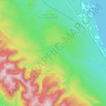
Name: Tsable River topographic map, elevation, terrain.
Average elevation: 493 m
Minimum elevation: 0 m
Maximum elevation: 1,495 m
Other topographic maps
Click on a map to view its topography, its elevation and its terrain.
Fanny Bay
Canada > British Columbia > Comox Valley Regional District > Area A (Baynes Sound) > Fanny Bay
Fanny Bay, Area A (Baynes Sound), Comox Valley Regional District, British Columbia, V0R 1T0, Canada
Average elevation: 36 m
Union Bay
Canada > British Columbia > Comox Valley Regional District > Area A (Baynes Sound) > Union Bay
Union Bay, Area A (Baynes Sound), Comox Valley Regional District, British Columbia, V0R 3B0, Canada
Average elevation: 39 m