
Make a donation
Libona topographic map
Click on the map to display elevation.
Make a donation
About this map
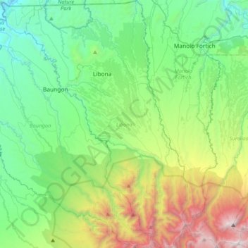
Name: Libona topographic map, elevation, terrain.
Location: Libona, Bukidnon, Northern Mindanao, 8706, Philippines (8.10976 124.64723 8.42552 124.86062)
Average elevation: 794 m
Minimum elevation: 16 m
Maximum elevation: 2,885 m
Make a donation
Other topographic maps
Click on a map to view its topography, its elevation and its terrain.
Make a donation
Make a donation
Make a donation
Make a donation
Make a donation
Make a donation
Mount Dulang-Dulang
Philippines > Bukidnon > Malaybalay
Mount Dulang-dulang, dubbed by Filipino mountaineers as "D2" and also known as Mount Katanglad, is the highest elevation peak in the Kitanglad Mountain Range, located in the north central portion of the province of Bukidnon in the island of Mindanao. It is the second highest mountain of the Philippines at…
Average elevation: 2,458 m
Make a donation
Make a donation
Make a donation
Mount Kalatungan
Philippines > Bukidnon > Pangantucan
Mount Kalatungan is the fifth highest mountain in the country with an elevation of 2,880 m (9,450 ft) asl. It is one of the several high elevation peaks in the Kalatungan Mountain Range in Bukidnon on the island of Mindanao, the second largest island in the Philippines.
Average elevation: 2,481 m
Make a donation
Valencia
The city's topography is characterized as flat to undulating hills with extensive plateaus and mountainous areas and cliffs on both eastern and western portions bounding the municipality of San Fernando on the east and the municipality of Talakag on the west. Its highest point is Mount Kalatungan in the…
Average elevation: 566 m
Make a donation
Make a donation
Make a donation
Make a donation
Make a donation
Make a donation
Make a donation
Make a donation
Make a donation
Make a donation
Make a donation
Make a donation
Mount Dulang-Dulang
Philippines > Bukidnon > Malaybalay
Mount Dulang-dulang, dubbed by Filipino mountaineers as "D2" and also known as Mount Katanglad, is the highest elevation peak in the Kitanglad Mountain Range, located in the north central portion of the province of Bukidnon in the island of Mindanao. It is the second highest mountain of the Philippines at…
Average elevation: 2,458 m
Make a donation
Mount Kitanglad
Philippines > Bukidnon > Impasugong
Due to its high elevation, several communications and broadcasting companies constructed relay stations at the summit.
Average elevation: 2,393 m
Make a donation
Lake Apo
Philippines > Bukidnon > Valencia
Lake Apo is a crater lake in Barangay Guinoyoran in the city of Valencia in Bukidnon province in the Philippines. It is located in a hilly area about 640 metres (2,100 ft) in elevation, about 11 kilometres (6.8 mi) WSW of the city poblacion (town center). Lake Apo was awarded the cleanest inland body of water…
Average elevation: 643 m
Make a donation