
Hennepin County topographic map
Interactive map
Click on the map to display elevation.
About this map
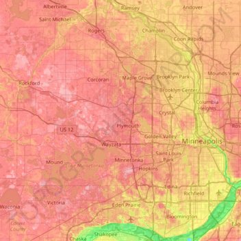
Name: Hennepin County topographic map, elevation, terrain.
Location: Hennepin County, Minnesota, United States of America (44.78513 -93.77020 45.24660 -93.17687)
Average elevation: 280 m
Minimum elevation: 190 m
Maximum elevation: 340 m
Other topographic maps
Click on a map to view its topography, its elevation and its terrain.
Cohasset
United States of America > Minnesota > Cohasset
Cohasset, Itasca County, Minnesota, 55721, United States of America
Average elevation: 395 m
Lismore
United States of America > Minnesota > Lismore
Lismore, Nobles County, Minnesota, United States of America
Average elevation: 510 m
Brownton
United States of America > Minnesota > Brownton
Brownton, McLeod County, Minnesota, United States of America
Average elevation: 314 m
Farmington
United States of America > Minnesota > Farmington
Farmington, Dakota County, Minnesota, 55024, United States of America
Average elevation: 280 m
Twin Lakes
United States of America > Minnesota > Twin Lakes
Twin Lakes, Freeborn County, Minnesota, 56089, United States of America
Average elevation: 384 m
Clearwater County
United States of America > Minnesota
Clearwater County, Minnesota, United States of America
Average elevation: 409 m
Hilltop
United States of America > Minnesota > Hilltop > Hilltop
Hilltop, Anoka County, Minnesota, 55421, United States of America
Average elevation: 273 m
Stevens County
United States of America > Minnesota
Stevens County, Minnesota, United States of America
Average elevation: 345 m
New Brighton
United States of America > Minnesota > New Brighton
New Brighton, Ramsey County, Minnesota, 55112, United States of America
Average elevation: 282 m
Round Lake
United States of America > Minnesota > Round Lake
Round Lake, Nobles County, Minnesota, 56167, United States of America
Average elevation: 472 m
Spring Valley
United States of America > Minnesota > Spring Valley
Spring Valley, Fillmore County, Minnesota, United States of America
Average elevation: 400 m
Beltrami County
United States of America > Minnesota
Beltrami County, Minnesota, United States of America
Average elevation: 386 m
Cottonwood County
United States of America > Minnesota
Cottonwood County, Minnesota, United States of America
Average elevation: 401 m
Wilkin County
United States of America > Minnesota
Wilkin County, Minnesota, United States of America
Average elevation: 320 m
Bemidji
United States of America > Minnesota > Bemidji
Bemidji, Beltrami County, Minnesota, 56601, United States of America
Average elevation: 417 m