Redmarley D'Abitot topographic map
Interactive map
Click on the map to display elevation.
About this map
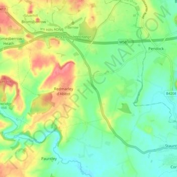
Name: Redmarley D'Abitot topographic map, elevation, terrain.
Average elevation: 46 m
Minimum elevation: 15 m
Maximum elevation: 95 m

Click on the map to display elevation.
Name: Redmarley D'Abitot topographic map, elevation, terrain.
Average elevation: 46 m
Minimum elevation: 15 m
Maximum elevation: 95 m