
Godavari topographic map
Interactive map
Click on the map to display elevation.
About this map
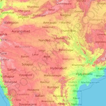
Name: Godavari topographic map, elevation, terrain.
Location: Godavari, Nizamabad, Telangana, 534452, India (16.68053 73.53222 20.05143 82.35356)
Average elevation: 380 m
Minimum elevation: -2 m
Maximum elevation: 1,440 m
Other topographic maps
Click on a map to view its topography, its elevation and its terrain.
Medak
India > Telangana > Medak mandal
Medak, Medak mandal, Medak District, Telangana, 502110, India
Average elevation: 462 m
Secunderabad
India > Telangana > Secunderabad
Secunderabad, Tirumalgiri mandal, Hyderabad, Telangana, 500003, India
Average elevation: 549 m
Gurudev Nagar
India > Telangana > Gurudev Nagar
Gurudev Nagar, Boath mandal, Adilabad, Telangana, India
Average elevation: 467 m
Prem Nagar
India > Telangana > Prem Nagar
Prem Nagar, Mutharam_Mahadevpur mandal, Jayashankar Bhupalapally District, Telangana, India
Average elevation: 147 m
Ward 105 Gachibowli
Ward 105 Gachibowli, Greater Hyderabad Municipal Corporation West Zone, Hyderabad, Serilingampalle mandal, Rangareddy, Telangana, India
Average elevation: 568 m