
Marathon County topographic map
Interactive map
Click on the map to display elevation.
About this map
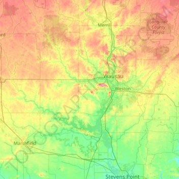
Name: Marathon County topographic map, elevation, terrain.
Location: Marathon County, Wisconsin, USA (44.68118 -90.31691 45.12053 -89.22335)
Average elevation: 398 m
Minimum elevation: 321 m
Maximum elevation: 563 m
Other topographic maps
Click on a map to view its topography, its elevation and its terrain.
Silver Creek
Silver Creek, Town of Almon, Shawano County, Wisconsin, 54416, USA
Average elevation: 371 m
Lake Evelyn
Lake Evelyn, County Road G, Pine Lake, Town of Oma, Iron County, Wisconsin, USA
Average elevation: 517 m
Anchor Island
Anchor Island, Town of Oma, Iron County, Wisconsin, USA
Average elevation: 462 m
Brookfield
USA > Wisconsin > Brookfield
Brookfield, Waukesha County, Wisconsin, USA
Average elevation: 251 m
Prong Lake
Prong Lake, Snowmobile and Logging Road, Town of Arbor Vitae, Vilas County, Wisconsin, USA
Average elevation: 503 m
Kangaroo Lake
USA > Wisconsin > Baileys Harbor
Kangaroo Lake, South Kangaroo Lake Drive, Baileys Harbor, Town of Baileys Harbor, Door County, Wisconsin, 54202, USA
Average elevation: 194 m
State-Langdon
State-Langdon, Madison, Dane County, Wisconsin, USA
Average elevation: 264 m