
Lake Rotootuauru topographic map
Interactive map
Click on the map to display elevation.
About this map
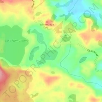
Name: Lake Rotootuauru topographic map, elevation, terrain.
Average elevation: 58 m
Minimum elevation: 3 m
Maximum elevation: 121 m
Other topographic maps
Click on a map to view its topography, its elevation and its terrain.
Kaipara Harbour
New Zealand > Auckland > Rodney > Pouto
Kaipara Harbour, Okahukura Road, Rodney, Auckland, New Zealand
Average elevation: 26 m
Lake Humuhumu
Lake Humuhumu, Pouto Road, Pouto, Kaipara District, Northland, New Zealand
Average elevation: 68 m
Lake Waingata
Lake Waingata, Pouto Road, Pouto, Kaipara District, Northland, New Zealand
Average elevation: 60 m
Lake Kanono
Lake Kanono, Pouto Road, Pouto, Kaipara District, Northland, New Zealand
Average elevation: 67 m
Lake Kahuparere
Lake Kahuparere, Pouto Road, Pouto, Kaipara District, Northland, New Zealand
Average elevation: 55 m
Lake Rototuna
Lake Rototuna, Pouto Road, Pouto, Kaipara District, Northland, New Zealand
Average elevation: 120 m
Lake Karaka
Lake Karaka, Pouto Road, Pouto, Kaipara District, Northland, New Zealand
Average elevation: 32 m