
Linn County topographic map
Interactive map
Click on the map to display elevation.
About this map
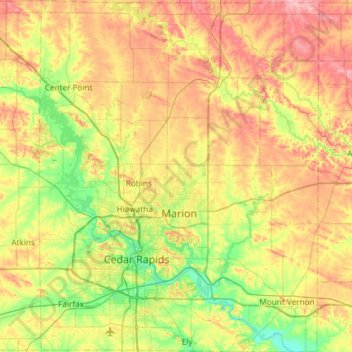
Name: Linn County topographic map, elevation, terrain.
Location: Linn County, Iowa, United States (41.85949 -91.83526 42.29905 -91.36329)
Average elevation: 261 m
Minimum elevation: 207 m
Maximum elevation: 335 m
Other topographic maps
Click on a map to view its topography, its elevation and its terrain.
Miles
United States > Iowa > Jackson County
Miles, Jackson County, Iowa, United States
Average elevation: 248 m
Clive
United States > Iowa > Polk County
Clive, Polk County, Iowa, 50325, United States
Average elevation: 287 m
Rodney
United States > Iowa > Monona County
Rodney, Monona County, Iowa, United States
Average elevation: 343 m
Iowa City
United States > Iowa > Johnson County
Iowa City, Johnson County, Iowa, United States
Average elevation: 216 m
Carmel
United States > Iowa > Sioux County
Carmel, Sioux County, Iowa, United States
Average elevation: 433 m
Westgate
United States > Iowa > Fayette County
Westgate, Fayette County, Iowa, United States
Average elevation: 333 m
Maxwell
United States > Iowa > Story County
Maxwell, Story County, Iowa, United States
Average elevation: 274 m
Cromwell
United States > Iowa > Union County
Cromwell, Union County, Iowa, 50842, United States
Average elevation: 387 m
Wanamaker
United States > Iowa > Ringgold County
Wanamaker, Ringgold County, Iowa, United States
Average elevation: 346 m
Hepburn
United States > Iowa > Page County
Hepburn, Page County, Iowa, United States
Average elevation: 327 m
Cromwell;Cromwell Post Office
United States > Iowa > Union County > Cromwell > Cromwell;Cromwell Post Office
Cromwell;Cromwell Post Office, Cromwell, Union County, Iowa, 50842, United States
Average elevation: 387 m
Mapleton
United States > Iowa > Monona County > Mapleton
Mapleton, Monona County, Iowa, United States
Average elevation: 351 m
Keosauqua
United States > Iowa > Van Buren County > Keosauqua
Keosauqua, Van Buren County, Iowa, United States
Average elevation: 192 m
Northwood
United States > Iowa > Northwood
Northwood, Worth County, Iowa, United States
Average elevation: 371 m
Cumming
United States > Iowa > Cumming
Cumming, Warren County, Iowa, United States
Average elevation: 290 m
Parnell
United States > Iowa > Iowa County
Parnell, Iowa County, Iowa, United States
Average elevation: 253 m
Cedar Rapids
United States > Iowa > Linn County > Cedar Rapids
Cedar Rapids, Linn County, Iowa, United States
Average elevation: 245 m