
Cromwell Community topographic map
Interactive map
Click on the map to display elevation.
About this map
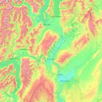
Name: Cromwell Community topographic map, elevation, terrain.
Average elevation: 876 m
Minimum elevation: 133 m
Maximum elevation: 2,593 m
Other topographic maps
Click on a map to view its topography, its elevation and its terrain.
Becks
New Zealand > Otago > Central Otago District > Vincent Community
Becks, Vincent Community, Central Otago District, Otago, 9377, New Zealand
Average elevation: 393 m
Cromwell
New Zealand > Otago > Central Otago District > Cromwell Community > Cromwell
Cromwell, Cromwell Community, Central Otago District, Otago, 9310, New Zealand
Average elevation: 330 m
Blue Lake
New Zealand > Otago > Central Otago District > Vincent Community > Saint Bathans
Blue Lake, Saint Bathans, Vincent Community, Central Otago District, Otago, New Zealand
Average elevation: 605 m
Kakanui Peak
New Zealand > Otago > Central Otago District
Kakanui Peak, Central Otago District, Otago, New Zealand
Average elevation: 1,169 m
Central Otago
New Zealand > Otago > Central Otago District > Vincent Community
Central Otago, Vincent Community, Central Otago District, Otago, 9035, New Zealand
Average elevation: 935 m
Shingle Creek
New Zealand > Otago > Central Otago District > Teviot Valley Community
Shingle Creek, Teviot Valley Community, Central Otago District, Otago, New Zealand
Average elevation: 307 m
Blackstone Hill
New Zealand > Otago > Central Otago District > Vincent Community
Blackstone Hill, Vincent Community, Central Otago District, Otago, 9377, New Zealand
Average elevation: 789 m
Alexandra
New Zealand > Otago > Central Otago District > Vincent Community
Alexandra, Vincent Community, Central Otago District, Otago, 9320, New Zealand
Average elevation: 241 m
Ranfurly
New Zealand > Otago > Central Otago District
Ranfurly, Central Otago District, Otago, 9332, New Zealand
Average elevation: 429 m
Ophir
New Zealand > Otago > Central Otago District > Vincent Community
Ophir, Vincent Community, Central Otago District, Otago, 9376, New Zealand
Average elevation: 338 m
Roxburgh
New Zealand > Otago > Central Otago District > Teviot Valley Community
Roxburgh, Teviot Valley Community, Central Otago District, Otago, 9500, New Zealand
Average elevation: 223 m
Clyde
New Zealand > Otago > Central Otago District > Vincent Community
Clyde, Vincent Community, Central Otago District, Otago, 9330, New Zealand
Average elevation: 316 m
Ida Valley
New Zealand > Otago > Central Otago District > Maniototo Community
Ida Valley, Maniototo Community, Central Otago District, Otago, New Zealand
Average elevation: 472 m
Muttontown
New Zealand > Otago > Central Otago District > Vincent Community > Clyde
Muttontown, Clyde, Vincent Community, Central Otago District, Otago, 9391, New Zealand
Average elevation: 207 m
Millers Flat
New Zealand > Otago > Central Otago District > Teviot Valley Community
Millers Flat, Teviot Valley Community, Central Otago District, Otago, 9572, New Zealand
Average elevation: 161 m
Naseby
New Zealand > Otago > Central Otago District
Naseby, Central Otago District, Otago, 9396, New Zealand
Average elevation: 617 m
Wedderburn
New Zealand > Otago > Central Otago District
Wedderburn, Central Otago District, Otago, 9395, New Zealand
Average elevation: 565 m