
Mount Tabor topographic map
Interactive map
Click on the map to display elevation.
About this map
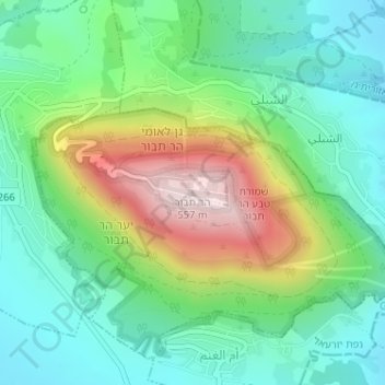
Name: Mount Tabor topographic map, elevation, terrain.
Location: Mount Tabor, North District, Israel (32.68706 35.38957 32.68716 35.38967)
Average elevation: 250 m
Minimum elevation: 101 m
Maximum elevation: 561 m
Other topographic maps
Click on a map to view its topography, its elevation and its terrain.
Mt. Hermon
Israel > North District > Golan Regional Council
Mt. Hermon, Golan Regional Council, Golan Heights Subdistrict, North District, Israel
Average elevation: 2,016 m
Mount Meron
Israel > North District > Merom HaGalil Regional Council
Mount Meron, Merom HaGalil Regional Council, North District, Israel
Average elevation: 943 m