
Hualien County topographic map
Interactive map
Click on the map to display elevation.
About this map
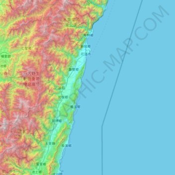
Name: Hualien County topographic map, elevation, terrain.
Location: Hualien County, Taiwan Province, Taiwan (23.09778 120.98660 24.37053 121.77382)
Average elevation: 686 m
Minimum elevation: 0 m
Maximum elevation: 3,857 m
Other topographic maps
Click on a map to view its topography, its elevation and its terrain.
Hehuanshan
Taiwan > Taiwan Province > Nantou County > Renai Township
Hehuanshan, Renai Township, Nantou County, Taiwan Province, Taiwan
Average elevation: 3,068 m
Green Island
Taiwan > Taiwan Province > Taitung County > Green Island
Green Island, Taitung County, Taiwan Province, Taiwan
Average elevation: 39 m
Orchid Island
Taiwan > Taiwan Province > Taitung County > Orchid Island
Orchid Island, Taitung County, Taiwan Province, Taiwan
Average elevation: 76 m