
Muñoz topographic map
Interactive map
Click on the map to display elevation.
Muñoz
It is situated 30 kilometres (19 mi) from Cabanatuan, 44 kilometres (27 mi) from Palayan, and 146 kilometres (91 mi) north of the capital Manila. Due to its rich topography and tropical climate, it is now home to agricultural research and technology centers, committed to the production of information and technological breakthroughs to promote rural development, productivity and food security.
About this map
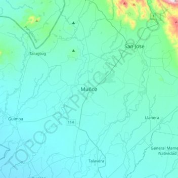
Name: Muñoz topographic map, elevation, terrain.
Location: Muñoz, Nueva Ecija, Central Luzon, 3119, Philippines (15.55354 120.74395 15.87354 121.06395)
Average elevation: 86 m
Minimum elevation: 20 m
Maximum elevation: 794 m
Other topographic maps
Click on a map to view its topography, its elevation and its terrain.
Talavera
The municipality's terrain is relatively flat, with slope ranging from 0 to 3%. Due to the flat topography, the land is suited for agricultural, commercial or industrial development. It is bordered by Cabanatuan, Llanera, Muñoz, Aliaga, General Mamerto Natividad, Santo Domingo and San Jose.
Average elevation: 49 m