
Fredericton topographic map
Interactive map
Click on the map to display elevation.
About this map
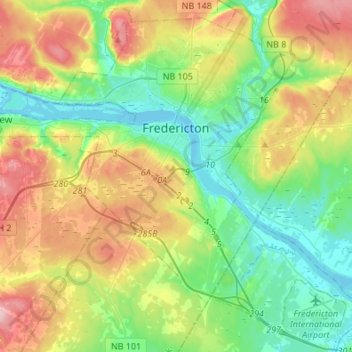
Name: Fredericton topographic map, elevation, terrain.
Location: Fredericton, York County, New Brunswick, Canada (45.86888 -66.78340 46.02813 -66.55035)
Average elevation: 70 m
Minimum elevation: -2 m
Maximum elevation: 172 m
At an altitude of about 17 m (56 ft) above sea level, Fredericton is nestled in the Pennsylvanian Basin. It differs markedly from the geologically older parts of the province. There are prominently two distinct areas in the region that are divided around the area of Wilsey Road, in the east end of the city. In the west side, the bedrock underneath the earth is topographically dominant, whereas the other is controlled by Pleistocene and recent deposits leading to the rivers (resulting in the area being shallow and wide). Fredericton and its surroundings are rich in water resources, which, coupled with highly arable soil, make the Fredericton region ideal for agriculture. The Saint John River and one of its major tributaries, the Nashwaak River, come together in Fredericton. The uninhabited parts of the city are heavily forested.
Other topographic maps
Click on a map to view its topography, its elevation and its terrain.
Saint Quentin Parish
Saint Quentin Parish, Restigouche County, New Brunswick, E8A 1H5, Canada
Average elevation: 341 m
Clarendon Parish
Clarendon Parish, Charlotte County, New Brunswick, Canada
Average elevation: 160 m
Bay of Fundy
Bay of Fundy, New Brunswick, B0P 1R0, Canada
Average elevation: 52 m
Bluff Hill
Bluff Hill, Douglas Parish, York County, New Brunswick, E3A 6M9, Canada
Average elevation: 93 m
Campbellton
Canada > New Brunswick > Campbellton
Campbellton, Restigouche County, New Brunswick, Canada
Average elevation: 62 m
Fredericton
Canada > New Brunswick > Sunbury County > Fredericton
Fredericton, Lincoln Parish, Sunbury County, New Brunswick, Canada
Average elevation: 70 m
Mount Atkinson
Mount Atkinson, Restigouche County, New Brunswick, Canada
Average elevation: 516 m
Saint John
Canada > New Brunswick > Saint John
Saint John, City of Saint John, Saint John County, New Brunswick, E2L 3L6, Canada
Average elevation: 44 m
Petit Rocher
Canada > New Brunswick > Petit Rocher
Petit Rocher, Beresford Parish, Gloucester County, New Brunswick, E8J 1S5, Canada
Average elevation: 10 m
Clarendon Parish
Clarendon Parish, Charlotte County, New Brunswick, Canada
Average elevation: 160 m
Campobello Island
Canada > New Brunswick > Campobello Island
Campobello Island, Campobello Parish, Charlotte County, New Brunswick, E5E 1G3, Canada
Average elevation: 6 m
Northumberland County
Northumberland County, New Brunswick, Canada
Average elevation: 177 m
Blackwater Lake
Blackwater Lake, Campbell Road, Charlotte County, New Brunswick, Canada
Average elevation: 81 m
Moncton
Canada > New Brunswick > Moncton
Moncton, Moncton Parish, Westmorland County, New Brunswick, Canada
Average elevation: 52 m