
Santa Barbara topographic map
Interactive map
Click on the map to display elevation.
About this map
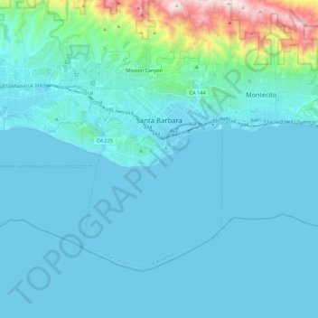
Name: Santa Barbara topographic map, elevation, terrain.
Average elevation: 119 m
Minimum elevation: -1 m
Maximum elevation: 1,155 m
Santa Barbara experiences a warm-summer Mediterranean climate (Köppen: Csb) characteristic of coastal California. Santa Barbara's weather was ranked number 1 in the United States in 2018 by U.S. News & World Report. Because the city lies along the ocean and parallel to the predominant westerly winds, sideshore and light onshore breezes moderate temperatures resulting in warmer winters and cooler summers compared with places farther inland. In the winter, storms reach California, some of which bring heavy rainfall but the rainshadow effect of the coastal mountains can at times moderate or enhance the rainfall depending on local storm wind flows. Local rainfall totals can be enhanced by orographic lift when storms are accompanied by southerly flow pushing moist air over the Santa Ynez mountains, producing greater rainfall than in other coastal areas. Diurnal temperature variation reaches a maximum in winter due to lower humidity and the absence of summer fog. On average, only 1.7 nights have freezing lows. Summers in Santa Barbara are mostly rainless due to the presence of a high-pressure area over the eastern Pacific, but summer showers can happen due to tropical hurricane/Monsoonal flows that rarely reach the region, thunderstorms could also occur during the North American Monsoon. In the fall, afternoon or evening downslope winds, locally called "Sundowners", can raise temperatures into the high 90s and drop humidities into the single digits, increasing the chance due to downed powerlines etc. and severity of wildfires in the foothills north of the city. Annual rainfall totals are highly variable and in exceptional years like 1940–1941 and 1997–1998 over 40 inches (1.0 m) of rain have fallen in a year, but in dry seasons less than 6 inches (150 mm) is not unheard of. Snow sometimes covers higher elevations of the Santa Ynez Mountains but is extremely rare in the city itself. The most recent accumulating snow to fall near sea level was in January 1949, when approximately two inches fell in the city.