
Shah Alam topographic map
Interactive map
Click on the map to display elevation.
About this map
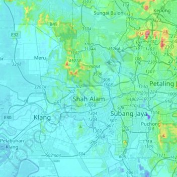
Name: Shah Alam topographic map, elevation, terrain.
Location: Shah Alam, Petaling, Selangor, Malaysia (2.94962 101.42773 3.22972 101.59139)
Average elevation: 28 m
Minimum elevation: -42 m
Maximum elevation: 324 m
Located in Klang Valley, Shah Alam topography is mostly flat, except in the northern part of the city where it features a prominent rolling hill.
Other topographic maps
Click on a map to view its topography, its elevation and its terrain.
Section 19
Malaysia > Selangor > SA > Section 19
Section 19, SA, Selangor, 40200, Malaysia
Average elevation: 10 m
Ampang Jaya
Malaysia > Selangor > Ampang Jaya
Ampang Jaya, Selangor, 51500, Malaysia
Average elevation: 162 m
Subang Jaya
Malaysia > Selangor > Subang Jaya
Subang Jaya, Selangor, 47610, Malaysia
Average elevation: 35 m