
Make a donation
Sunnybank Hills topographic map
Click on the map to display elevation.
Make a donation
About this map
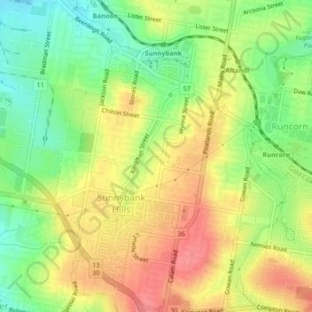
Name: Sunnybank Hills topographic map, elevation, terrain.
Location: Sunnybank Hills, Greater Brisbane, Queensland, Australia (-27.61166 153.03821 -27.57573 153.06699)
Average elevation: 59 m
Minimum elevation: 21 m
Maximum elevation: 96 m
Make a donation
Other topographic maps
Click on a map to view its topography, its elevation and its terrain.
Make a donation
Make a donation
Torres Strait
Several clusters of islands lie in the Strait, collectively called the Torres Strait Islands. There are at least 274 of these islands, of which 17 have present-day permanent settlements. These islands have a variety of topographies, ecosystems and formation history. Several of those closest to the New Guinea…
Average elevation: 0 m
Make a donation
Make a donation
Make a donation
Koala Park Bushland Conservation Reserve
Australia > Queensland > Sunshine Coast Regional > Nambour
Average elevation: 35 m
Make a donation
Make a donation
Make a donation