
Guysborough County topographic map
Interactive map
Click on the map to display elevation.
About this map
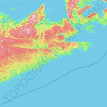
Name: Guysborough County topographic map, elevation, terrain.
Location: Guysborough County, Nova Scotia, Canada (44.71323 -62.71213 45.65310 -60.56170)
Average elevation: 41 m
Minimum elevation: -2 m
Maximum elevation: 306 m
Other topographic maps
Click on a map to view its topography, its elevation and its terrain.
Annapolis Valley
Canada > Nova Scotia > Municipality of the County of Kings > Auburn
Average elevation: 77 m
Anse à Digue
Canada > Nova Scotia > Municipality of the County of Inverness > Chéticamp Island
Average elevation: 12 m