
Iowa County topographic map
Interactive map
Click on the map to display elevation.
About this map
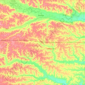
Name: Iowa County topographic map, elevation, terrain.
Location: Iowa County, Iowa, United States of America (41.50959 -92.30165 41.86295 -91.82700)
Average elevation: 249 m
Minimum elevation: 206 m
Maximum elevation: 288 m
Other topographic maps
Click on a map to view its topography, its elevation and its terrain.
Council Bluffs
United States of America > Iowa > Council Bluffs
Council Bluffs, Pottawattamie County, Iowa, United States of America
Average elevation: 315 m
Des Moines
United States of America > Iowa > Des Moines
Des Moines, Polk County, Iowa, United States of America
Average elevation: 264 m
Keystone
United States of America > Iowa > Keystone
Keystone, Benton County, Iowa, 52249, United States of America
Average elevation: 272 m
Plymouth County
United States of America > Iowa
Plymouth County, Iowa, United States of America
Average elevation: 399 m
Renwick
United States of America > Iowa > Renwick
Renwick, Humboldt County, Iowa, United States of America
Average elevation: 347 m
Hawarden
United States of America > Iowa > Hawarden
Hawarden, Sioux County, Iowa, United States of America
Average elevation: 365 m
Dedham
United States of America > Iowa > Dedham
Dedham, Carroll County, Iowa, United States of America
Average elevation: 395 m
Riverton
United States of America > Iowa > Riverton
Riverton, Fremont County, Iowa, United States of America
Average elevation: 292 m
Ames
United States of America > Iowa > Ames
Ames, Story County, Iowa, United States of America
Average elevation: 292 m
Pottawattamie County
United States of America > Iowa
Pottawattamie County, Iowa, United States of America
Average elevation: 357 m