
Make a donation
Lake Wairarapa topographic map
Click on the map to display elevation.
Make a donation
About this map
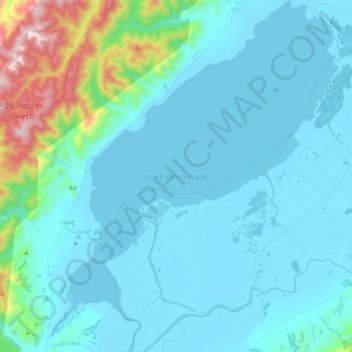
Name: Lake Wairarapa topographic map, elevation, terrain.
Average elevation: 106 m
Minimum elevation: -4 m
Maximum elevation: 812 m
South Wairarapa District trails, hiking, mountain biking, running and outdoor activities
Make a donation
Other topographic maps
Click on a map to view its topography, its elevation and its terrain.
Featherston
New Zealand > Wellington > South Wairarapa District > Featherston Community
Average elevation: 125 m
South Featherston
New Zealand > Wellington > South Wairarapa District > Featherston Community > Featherston
Average elevation: 26 m
Featherston
New Zealand > Wellington > South Wairarapa District > Featherston Community
Average elevation: 125 m
Featherston
New Zealand > Wellington > South Wairarapa District > Featherston Community
Average elevation: 125 m
Make a donation
South Featherston
New Zealand > Wellington > South Wairarapa District > Featherston Community > Featherston
Average elevation: 26 m
South Featherston
New Zealand > Wellington > South Wairarapa District > Featherston Community > Featherston
Average elevation: 26 m
Lake Ōnoke
New Zealand > Wellington > South Wairarapa District > Featherston Community
Average elevation: 2 m