Geolocate

Mount Timpanogos topographic map

Interactive map

Click on the map to display elevation.

About this map

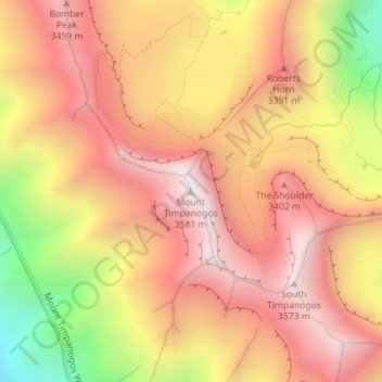
Name: Mount Timpanogos topographic map, elevation, terrain.

Location: Mount Timpanogos, Utah County, Utah, USA (40.39084 -111.64604 40.39094 -111.64594)

Average elevation: 3,144 m

Minimum elevation: 2,428 m

Maximum elevation: 3,573 m

Other topographic maps

Click on a map to view its topography, its elevation and its terrain.

Orem

USA > Utah > Orem

Orem, Utah County, Utah, USA

Average elevation: 1,457 m

Wasatch Range

USA > Utah

Wasatch Range, Salt Lake County, Utah, USA

Average elevation: 1,880 m

The Blues

USA > Utah

The Blues, Garfield County, Utah, USA

Average elevation: 2,172 m

Great Salt Lake

USA > Utah

Great Salt Lake, Box Elder County, Utah, USA

Average elevation: 1,380 m

Kings Peak

USA > Utah

Kings Peak, Duchesne County, Utah, USA

Average elevation: 3,741 m

Uinta Mountains

USA > Utah

Uinta Mountains, Duchesne County, Utah, USA

Average elevation: 2,363 m

Black Mountains

USA > Utah

Black Mountains, Juab County, Utah, USA

Average elevation: 1,619 m

Squaw Spring

USA > Utah

Squaw Spring, Squaw Flat Loop, San Juan County, Utah, USA

Average elevation: 1,565 m

Paria River

USA > Utah

Paria River, Kane County, Utah, 84718, USA

Average elevation: 1,802 m