
Lake Kohangapiripiri topographic map
Interactive map
Click on the map to display elevation.
About this map
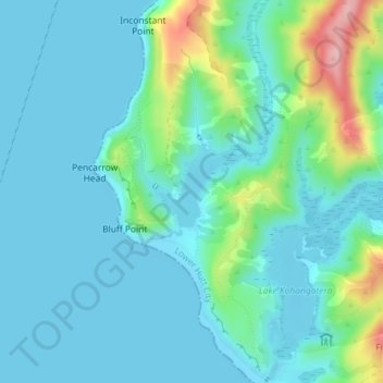
Name: Lake Kohangapiripiri topographic map, elevation, terrain.
Average elevation: 32 m
Minimum elevation: -2 m
Maximum elevation: 169 m
Other topographic maps
Click on a map to view its topography, its elevation and its terrain.
Days Bay
New Zealand > Wellington > Lower Hutt
Days Bay, Lower Hutt, Wellington, 5013, New Zealand
Average elevation: 74 m
Somes Island
New Zealand > Wellington > Lower Hutt
Somes Island, Lower Hutt, Wellington, New Zealand
Average elevation: 1 m
Hutt River
New Zealand > Wellington > Lower Hutt
Hutt River, Lower Hutt, Lower Hutt City, Wellington, 5019, New Zealand
Average elevation: 97 m
Towai
New Zealand > Wellington > Lower Hutt
Towai, Lower Hutt, Lower Hutt City, Wellington, 5010, New Zealand
Average elevation: 123 m