
Guildford topographic map
Interactive map
Click on the map to display elevation.
About this map
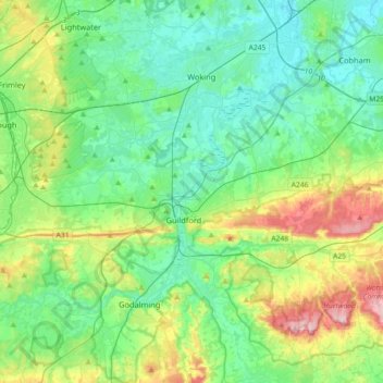
Name: Guildford topographic map, elevation, terrain.
Location: Guildford, Surrey, South East England, England, United Kingdom (51.17319 -0.74834 51.33152 -0.38717)
Average elevation: 74 m
Minimum elevation: 12 m
Maximum elevation: 256 m
Other topographic maps
Click on a map to view its topography, its elevation and its terrain.
Puttenham Common
United Kingdom > England > Surrey > Guildford > Puttenham
Puttenham Common, Murtmead Lane, Puttenham, Guildford, Surrey, England, GU3 1BQ, United Kingdom
Average elevation: 80 m
Farley Green
United Kingdom > England > Surrey > Guildford
Farley Green, Albury, Guildford, Surrey, England, GU5 9EE, United Kingdom
Average elevation: 114 m