
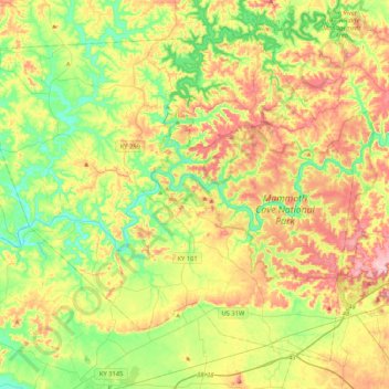
Edmonson County topographic map
Interactive map
Click on the map to display elevation.
About this map
Name: Edmonson County topographic map, elevation, terrain.
Location: Edmonson County, Kentucky, United States (37.05312 -86.46872 37.34086 -86.04896)
Average elevation: 196 m
Minimum elevation: 123 m
Maximum elevation: 300 m
Other topographic maps
Click on a map to view its topography, its elevation and its terrain.
Liberty
United States > Kentucky > Casey County
Liberty, Casey County, Kentucky, United States
Average elevation: 276 m
Villa Hills
United States > Kentucky > Kenton County
Villa Hills, Kenton County, Kentucky, United States
Average elevation: 224 m
La Grange
United States > Kentucky > Oldham County
La Grange, Oldham County, Kentucky, 40031, United States
Average elevation: 246 m
Lexington
United States > Kentucky > Fayette County
Lexington, Fayette County, Kentucky, United States
Average elevation: 281 m
Mayfield
United States > Kentucky > Graves County
Mayfield, Graves County, Kentucky, 42066, United States
Average elevation: 145 m
Campton
United States > Kentucky > Wolfe County
Campton, Wolfe County, Kentucky, United States
Average elevation: 323 m
New
United States > Kentucky > Owen County
New, Owen County, Kentucky, United States
Average elevation: 243 m
Ninevah
United States > Kentucky > Anderson County > Ninevah
Ninevah, Anderson County, Kentucky, United States
Average elevation: 237 m
Clifton
United States > Kentucky > Jefferson County > Louisville > Clifton
Clifton, Louisville, Jefferson County, Kentucky, 40206, United States
Average elevation: 147 m
Forest Hills
United States > Kentucky > Forest Hills
Forest Hills, Jefferson County, Kentucky, United States
Average elevation: 202 m
Fort Thomas
United States > Kentucky > Fort Thomas
Fort Thomas, Campbell County, Kentucky, 41075, United States
Average elevation: 192 m
Baptist
United States > Kentucky > Baptist
Baptist, Wolfe County, Kentucky, 41301, United States
Average elevation: 320 m